Purton

Museum
and Historical Society
The 1738 Purton Enclosure Act and the 1744 Map
After the Elizabethan Enclosure Acts of 1594 and 1598 (quoted in Mrs Richardson, History of Purton) and in 1733 an enclosure of 260 acres of Moomes Leaze at the western end of Purton Common (Quoted VCH), a further 1200 acres of Common pasture land around Purton called in the Act “Purton Common and Purton Stoak (sic) Common” was enclosed by the 1738 Enclosure Act.
Prior to Enclosure commoners had rights to graze a set number of animals on the commons. It was not a free-for-all, but grazing was difficult to police and commons were frequently over-grazed and the quality of the grazing declined. The Act allocated land to commoners in proportion to the grazing rights they already had; this land was enclosed by fences or hedges and became the property of the commoner. They were then able to keep whatever stock they wished on the land and also improve the quality of the grazing.
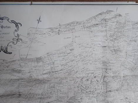
6 years later after the 1738 Act was passed a detailed map was produced showing who-owned-what in Purton parish in 1744.
Judith Rouse has transcribed the 1738 Enclosure Act and her daughter Emma was responsible for the photography and creating the digital images of the 1744 map (Emma Rouse BA Hons, MA, MiFA).
To view the images, right click on the image, then click on "Magnify Image",. Click the + sign on the magnifying glass to enlarge further. However by doing this you lose some clarity so there are other images of smaller areas below the first batch.


On the map houses are depicted with a tiny drawing with a number beside it. On the bottom left hand corner of the map is a panel showing owners of the houses in the parish so you can see who owned which house and where it was located. Sorry, there is some overlap in the images of the list
List of Houses


Explanation of the Houses

Close-up Images - North west of the parish

This first section shows images of the north-west corner of the parish. Right click on the image to enlarge


Close up images - south-east of parish (Purton village)


North-east corner of parish (Purton Stoke)


South-west corner of the parish (Ringsbury and Greenhill)


